For decades, PDF maps have been the standard tool that builders and real estate developers rely on to present land layouts to prospective buyers. Flat, printed or digitally shared, these documents do the basic job of showing plot boundaries and dimensions. But in today's competitive market, "basic" is no longer enough.
Across India and beyond, a growing number of builders are making a decisive shift — from static PDF maps to interactive 3D plot views. The reasons are clear: better client engagement, faster decisions, reduced confusion, and ultimately more sales. This article breaks down exactly why this transition is happening and what it means for the future of real estate marketing.
The Problem with PDF Maps
PDF maps have served builders well for many years, but they come with a set of fundamental limitations that are becoming increasingly difficult to ignore in a digital-first world.
They Are Static and One-Dimensional
A PDF map is a frozen snapshot of a layout. Buyers cannot rotate it, zoom into specific areas without losing clarity, or explore how one plot relates to its surroundings in three-dimensional space. For someone trying to understand terrain elevation, road access, or how sunlight will fall on their prospective plot, a flat PDF offers almost no useful information.
They Require Trained Interpretation
Reading a technical layout map is a skill. Scale bars, survey notations, plot numbers, and boundary markings are second nature to engineers and architects — but to the average buyer, they are confusing and intimidating. This friction creates a barrier between the builder and the sale. Clients who cannot confidently interpret what they are looking at will hesitate, delay, or walk away entirely.
They Cannot Communicate Terrain and Elevation
Land is not flat. Slopes, contours, natural drainage paths, and elevation changes all affect the usability and value of a plot. A PDF cannot convey any of this. Buyers who purchase a plot based on a PDF alone are often surprised — sometimes unpleasantly — when they visit the site and discover terrain features they were not aware of.
They Are Difficult to Share Interactively
Sending a PDF over WhatsApp or email works, but it ends there. The buyer cannot interact with it, highlight areas, ask questions about specific sections in context, or explore it at their own pace. Every follow-up question requires the builder to re-engage manually, slowing the entire sales process.
They Become Outdated Quickly
As plots are sold, layouts are revised, or phases are added, PDF maps become stale. Builders end up managing multiple versions of the same document, and buyers frequently receive outdated information. This leads to confusion, disputes, and erosion of trust.
The Shift to 3D Visualization
The real estate industry is not new to technological change. From newspaper classifieds to online listings, from printed brochures to drone videos, each shift has been driven by what helps buyers feel more confident and informed. 3D plot visualization is the next natural step in that evolution.
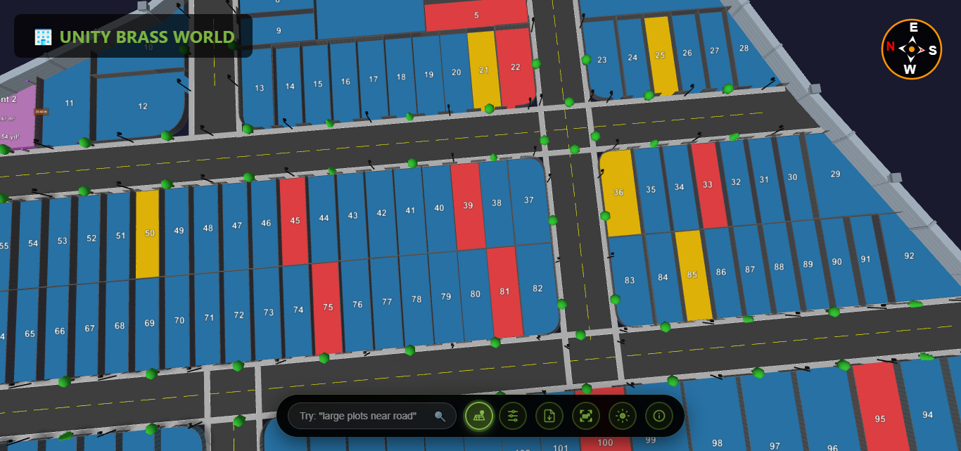
Modern tools make it possible to convert a standard PDF layout map into a fully interactive 3D model in minutes. Buyers can explore the entire layout from any angle, drill into individual plots, understand the terrain, and even measure distances — all without setting foot on the site.
This is not a luxury reserved for large developers. Platforms like Plotex have made PDF to 3D map conversion accessible to builders of all sizes, requiring no technical expertise and no specialized hardware. The result is a presentation experience that was previously impossible outside of expensive architectural rendering studios.
Key Benefits Driving the Switch
1 Dramatically Improved Client Engagement
There is a fundamental difference between handing a client a PDF and handing them an interactive 3D model. One is a document. The other is an experience. When buyers can rotate a layout, zoom into their preferred plot, and see exactly how it sits within the broader development, their engagement level rises sharply.
Builders who have made the switch report that client meetings become collaborative rather than one-sided. Instead of the builder explaining what a PDF shows, the client actively explores the model, asks specific questions, and begins mentally inhabiting the space. This shift in dynamic — from passive viewing to active exploration — is a powerful driver of purchase confidence.
- Clients spend significantly more time engaging with 3D views than PDF documents
- Interactive models prompt more specific, informed questions from buyers
- Buyers develop stronger emotional attachment to plots they can explore visually
- Sales presentations become more dynamic and memorable
2 Faster Sales Cycles and Higher Conversion Rates
One of the most tangible outcomes of adopting builders 3D visualization tools is the reduction in time between first inquiry and final booking. When buyers can clearly understand what they are purchasing, they eliminate the hesitation that typically stretches sales cycles over weeks or months.
The guesswork is gone. Questions like "Which way does the plot face?" or "How far is it from the main road?" can be answered instantly by exploring the 3D model. This self-service clarity removes the need for multiple site visits, repeated explanations, and drawn-out back-and-forth communication.
- Builders report up to 40% reduction in average time to close deals
- Fewer objections arise during negotiations when buyers have clear visual information
- Remote buyers convert at significantly higher rates when given 3D access
- Online listings with 3D views generate more qualified inquiries
3 Greater Accuracy and Reduced Disputes
One of the hidden costs of PDF-based sales is the disputes and misunderstandings that arise after purchase. Buyers who misread boundaries, misunderstand plot dimensions, or were unaware of terrain features often come back with complaints — or worse, legal challenges.
3D visualization tools with built-in measurement capabilities allow buyers to verify dimensions, understand boundary positions, and assess terrain before signing. This transparency protects both the buyer and the builder, creating a foundation of trust that reduces post-sale friction dramatically.
- Buyers can measure plot dimensions directly within the 3D view
- Terrain features and slopes are clearly visible, eliminating post-purchase surprises
- Boundary positions are unambiguous in a 3D spatial context
- Shared interactive links create a documented record of what was presented
4 Remote Selling Without Compromise
India's real estate market has always included buyers from outside the local area — NRIs, buyers from other cities, investors who cannot visit sites easily. For these buyers, a PDF map has historically been a poor substitute for a site visit, creating hesitation that prevents remote sales from closing.
A 3D plot view fundamentally changes this equation. A buyer in Dubai or Bengaluru can explore a layout in Chennai or Hyderabad with the same depth of understanding as someone who visited in person. The experience bridges the geographic gap that PDF documents cannot cross.
- Enable confident purchasing decisions without requiring a site visit
- Share interactive 3D links via WhatsApp, email, or any messaging platform
- Conduct live virtual walkthroughs during video calls
- Reach and convert NRI buyers who represent high-value, motivated customers
5 Stronger Brand Positioning
The tools a builder uses to present their projects communicate something about how they operate. A builder who shows up to a client meeting with an interactive 3D layout immediately differentiates themselves from competitors still relying on rolled-up paper maps or basic PDFs.
This is not superficial differentiation. It signals investment in quality, attention to the client experience, and confidence in the product being sold. In markets where multiple builders are competing for the same buyer, this professional edge can be the deciding factor.
- Position your brand as technologically advanced and client-focused
- Create shareable, impressive presentations that buyers pass along to family and advisors
- Build a reputation that attracts quality buyers and referrals
- Stand apart from competitors still relying on outdated presentation methods
Real-World Use Cases
The shift from PDF to 3D is already underway across different segments of the real estate market. Here is how builders in various contexts are applying this technology.
Township and Plotted Development Projects
Large plotted developments with hundreds of plots across multiple phases are particularly well suited to 3D visualization. Buyers need to understand how their specific plot relates to amenities, roads, green spaces, and neighboring plots. A PDF showing all of this at once becomes cluttered and difficult to read. A 3D model allows buyers to navigate intuitively, filtering to their area of interest and exploring it at their own pace.
Builders managing township projects have found that 3D models reduce the volume of inbound queries significantly — buyers answer many of their own questions by exploring the model, freeing up sales staff for higher-value conversations.
Hill Station and Resort Plots
Terrain is everything when it comes to hill station properties. Buyers want to know which plots have valley views, which are on flatter ground, and how elevation affects privacy and accessibility. This is information that a PDF is completely unable to convey. A 3D terrain model makes these characteristics immediately legible, turning terrain complexity from a sales obstacle into a sales advantage.
Commercial and Industrial Layouts
Commercial plot buyers — warehouse operators, manufacturers, logistics companies — have highly specific requirements around plot dimensions, road access, and surrounding infrastructure. A 3D view allows them to assess these factors quickly and precisely, accelerating decision-making for buyers who are often evaluating multiple options simultaneously.
Pre-Launch Marketing
Builders launching new projects before construction begins face the challenge of selling something that does not yet exist. 3D layout visualization is an ideal tool for pre-launch phases, giving buyers a rich and credible sense of the project without requiring physical infrastructure to be in place. Early buyers who feel confident about what they are purchasing commit sooner, providing builders with the early revenue needed to fund development.
PDF to 3D Map Conversion: What the Process Actually Looks Like
A common misconception is that converting a PDF map to a 3D view requires months of work and a team of technical specialists. Modern platforms have made this process remarkably straightforward.
With Plotex, the workflow is designed to be accessible to anyone managing a real estate project, regardless of technical background. Here is what the process typically involves:
- Upload your existing PDF layout - Your current map, however it exists, is the starting point. Plotex accepts standard layout files and begins the conversion process immediately.
- Automatic 3D model generation - The platform processes the layout and generates an interactive 3D model, preserving plot numbers, boundaries, road markings, and other key features from the original document.
- Review and customize - Add labels, highlight available plots, mark amenities, and adjust the view to best represent your project. No design skills are required.
- Share directly with buyers - Generate a shareable link that buyers can open on any device — smartphone, tablet, or desktop — without installing any software.
- Update as the project evolves - As plots are sold or the layout changes, updates can be made quickly, ensuring buyers always see current information.
The entire process from PDF upload to shareable 3D link can be completed in a matter of minutes. For builders managing multiple projects, this means the barrier to adopting 3D visualization is lower than most assume.
Addressing Common Concerns
Will buyers actually use it?
This is the most frequent concern builders raise when considering the switch. The answer, consistently, is yes. Buyers who are given access to an interactive 3D view explore it thoroughly. The intuitive nature of 3D navigation — the same kind of interaction people use with maps on their phones every day — means there is virtually no learning curve. Buyers engage with 3D models naturally and enthusiastically.
Is it expensive?
The cost of 3D visualization tools has dropped dramatically as the technology has matured. Platforms like Plotex offer accessible pricing that makes this technology viable for individual builders and smaller development companies, not just large corporate developers. When weighed against the value of even a single additional sale, the return on investment is clear.
Does it replace site visits?
For many buyers, 3D visualization reduces the number of site visits needed rather than eliminating them entirely. Buyers arrive at site visits better informed, with more specific questions, and with a stronger existing connection to the plot they are interested in. This makes site visits more productive and more likely to result in a purchase decision.
How to Make the Switch with Plotex
Getting started with Plotex requires no long-term commitment, no technical setup, and no specialized knowledge. Builders can begin with a single project and expand their use of the platform as they see results.
The platform is designed specifically for the needs of real estate builders and developers in the Indian market, with features built around the typical workflows of plotted development projects. From township layouts to commercial plots, the tool handles the variety of project types that builders work with day to day.
Making the switch from PDF to 3D does not mean abandoning your existing documentation. Your PDF maps remain valid and useful internally. What changes is what you put in front of buyers — and that change, as builders who have made the transition consistently report, makes a measurable difference to sales outcomes.
The builders who adopt this technology now are building a competitive advantage that will only grow as buyer expectations continue to rise. The question is no longer whether to make the switch — it is how quickly you can do it.
Convert Your PDF Maps to 3D Views Today
Join builders across India who are closing deals faster with interactive 3D plot visualization. Upload your layout and see the difference in minutes.
Try Plotex Free